Routes · 7 min
Tokyo route test: the proposed order cut straight-line distance by 15.2%
We fixed four coordinates, compared the original and proposed orders, and found that the model’s own 8.5 km total did not match our independent calculation.
TripNotePlan Development and Operations Team
Published · Updated
How this guide was made
- We fixed the same four Tokyo coordinates and compared the original input order with the order proposed by an AI route pass.
- We independently calculated coordinate-to-coordinate straight-line totals instead of treating the model’s distance estimate as a verified road distance.
Verification evidence
- Test case
route-tokyo-4-stops-v1- Platform
- Web /app
- Tested
- Build reference
9563001- Source record language
- Korean
The original and proposed orders from the 2026-07-16 controlled result were retained as a normalized audit record, then replayed in web /app on 2026-08-31 at Step 2 checkpoint 9563001. The response JSON is an audit transcription, not a verbatim provider response, and the audit uses coordinate-to-coordinate Haversine distance rather than a road route.
Screen records
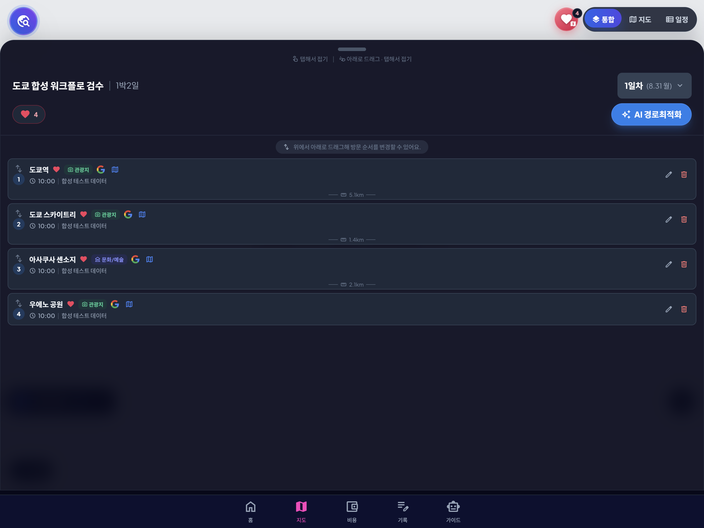
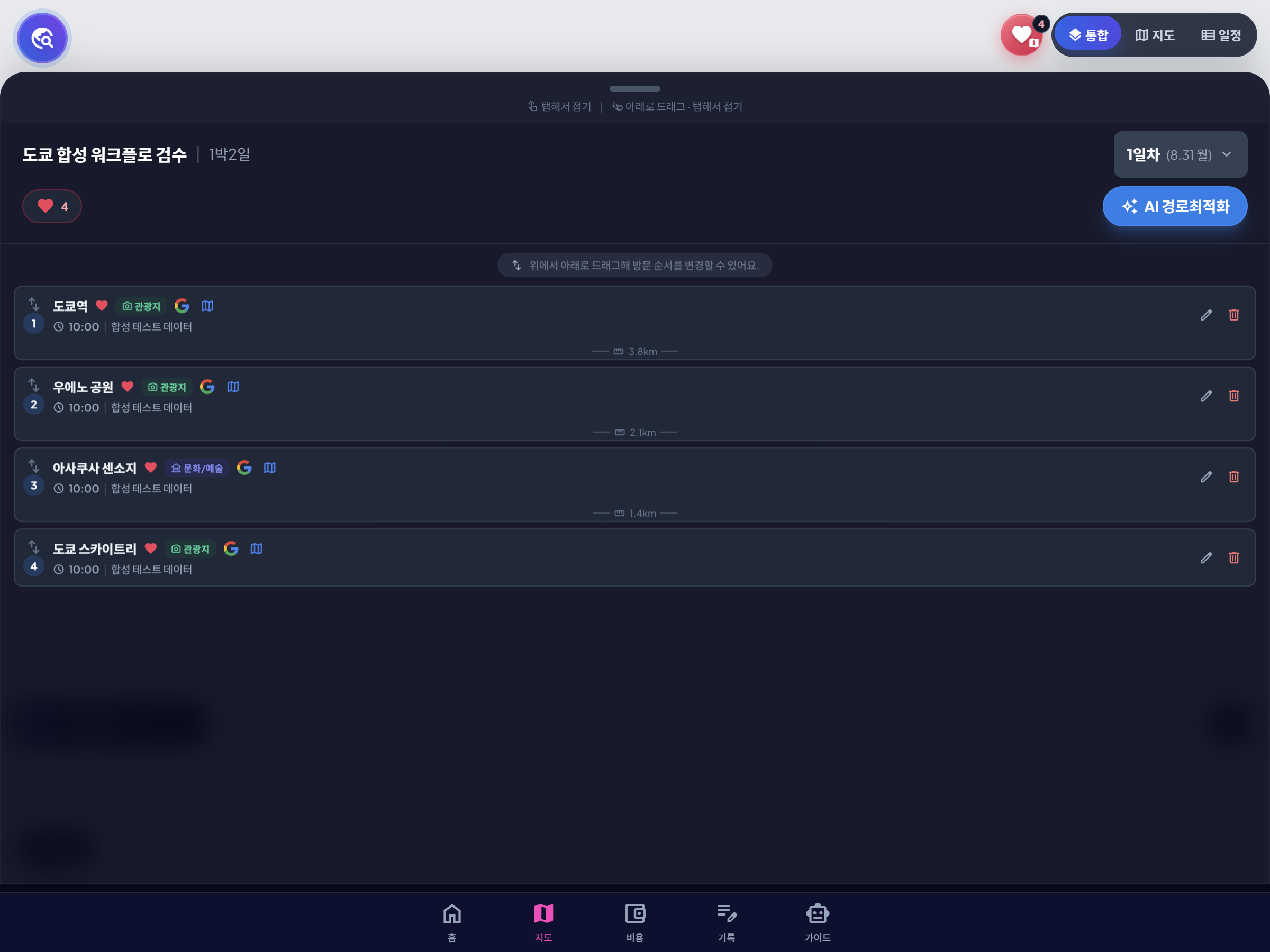
Downloadable audit files
-
Route request JSON · JSON
Controlled input preserving the four places and original order
-
Route response audit JSON · JSON
Normalized transcription of the proposed order and model distance estimate
-
Haversine audit CSV · CSV
Independent segment and total straight-line calculations for both orders
We tested route ordering with the same four Tokyo coordinates in both cases. The original order totaled about 8.54 km in coordinate-to-coordinate straight lines. The proposed order totaled about 7.24 km, a reduction of 1.30 km or 15.2%. This does not mean the walking or transit route became 15.2% shorter; it means the proposed sequence was spatially cleaner under one limited calculation.
The input was fixed before comparing the order
The four places were Tokyo Station, Tokyo Skytree, Sensoji, and Ueno Park. The original list moved from Tokyo Station to Skytree, then back through Sensoji to Ueno.
We used the coordinates below only to reproduce the order comparison. A straight line between coordinates is not a route through streets, stations, or rail networks.
| Original order | Place | Latitude | Longitude |
|---|---|---|---|
| 1 | Tokyo Station | 35.681236 | 139.767125 |
| 2 | Tokyo Skytree | 35.710063 | 139.810700 |
| 3 | Sensoji | 35.714765 | 139.796655 |
| 4 | Ueno Park | 35.714755 | 139.773431 |
The proposed order moved west to east
The proposed sequence was Tokyo Station → Ueno Park → Sensoji → Tokyo Skytree. Under the same straight-line method, that order reduced the sum from about 8.54 km to 7.24 km.
The percentage belongs to this exact place set, start point, and distance definition. It should not be presented as an expected saving for other trips.
| Version | Order | Total | Difference |
|---|---|---|---|
| Original | Station → Skytree → Sensoji → Ueno | 8.54 km | Baseline |
| Proposed | Station → Ueno → Sensoji → Skytree | 7.24 km | 1.30 km lower |
| Reduction | Same four coordinates | 15.2% | Straight-line only |
Why we rejected the model’s distance number
The response also reported an estimated total distance of 8.5 km for the proposed order. That did not match the 7.24 km straight-line sum, and the response did not provide enough detail to reproduce its distance definition.
We therefore kept the ordering insight but did not treat the reported total as verified road distance. A traveler should calculate each segment with the actual mode—walking, transit, or driving—using a current route service.
When the human-edited route should be longer
Timed tickets, restaurant reservations, hotel location, luggage, and accessibility can make the shortest-looking sequence impractical. Ueno in the morning and Skytree at a booked evening time may be reasonable even if another order is shorter.
Use optimization to identify unnecessary backtracking, then lock the constraints that the calculation did not know. In TripNotePlan, the proposed order can be edited after the map review instead of being accepted as final.
- Include the hotel or real starting point.
- Lock timed reservations before moving other stops.
- Check every segment with the transport mode you will use.
- Keep meals, rest, and station navigation in the day.
Action checklist
- Hold the place set and starting point constant when comparing orders.
- Label straight-line calculations separately from real routes.
- Reject distance totals that cannot be reproduced.
- Edit the final order around bookings, hotel, meals, and access needs.